
In brief
A BBC Verify investigation reveals that the Israeli military is controlling more territory in Gaza than previously agreed upon in ceasefire talks with Hamas. Satellite images and videos show Israeli markers placed hundreds of meters deeper into Gaza than the recognized 'Yellow Line', raising questions about Israeli military strategy and civilian safety in the region.
The Israeli military is exerting control over more of Gaza than expected from the ceasefire deal with Hamas, a BBC Verify analysis has found.
Under the first stage of the deal, Israel agreed to retreat to a boundary running along the north, south and east of Gaza. The divide was marked by a yellow line on maps released by the military and has become known as the Yellow Line.
But new videos and satellite images show that markers placed by Israeli troops in two areas to mark the divide have been positioned hundreds of metres deeper inside the strip than the expected withdrawal line.
Israeli Defence Minister Israel Katz - who instructed troops to place the yellow blocks as markers - warned that anyone crossing the line will be met with fire. There have already been at least two deadly incidents near the boundary line.
The Israel Defense Forces (IDF) did not address the allegations when approached by BBC Verify, stating simply that: IDF troops under the Southern Command have begun marking the Yellow Line in the Gaza Strip to establish tactical clarity on the ground.
There has been a consistent lack of clarity as to where exactly the boundary will be imposed, with three separate maps posted by the White House, Donald Trump and the Israeli military in the run up to the ceasefire agreement which came into force on 10 October.
On 14 October the IDF issued the latest version marking the Yellow Line on their online map, which is used to communicate its position to people in Gaza.
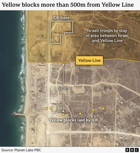
But in the north, near the al-Atatra neighbourhood, drone footage from the IDF showed that a line of six yellow blocks were up to 520m further inside the Strip than would have been expected from the IDF maps.
Footage geolocated by BBC Verify showed workers using bulldozers and diggers to move the heavy yellow blocks and place them along the coastal al-Rashid road.
A similar situation was visible in southern Gaza, where a satellite image taken on 19 October showed 10 markers erected near the city of Khan Younis. The line of blocks ranges between 180m-290m inside the Yellow Line set out by the IDF.
If these two sections of boundary were typical of how the markers were being placed along the entirety of the line then Israel would be exerting control over a notably larger area than expected from the ceasefire agreement.
Multiple analysts who spoke to BBC Verify suggested that the blocks were intended to create a buffer zone between Palestinians and IDF personnel. One expert said the move would be consistent with a long-term strategic culture which seeks to insulate Israel from nearby territories it does not fully control.
Three experts who spoke to BBC Verify suggested that the disparity between the markers and the IDF map was an intentional design to warn civilians they are approaching an area of increased risk.
The legal status of the boundary has been questioned, with experts emphasizing Israel's obligations under the law of armed conflict should remain, stating that it can only target enemy fighters or those directly participating in hostilities.
Since the ceasefire came into effect, the IDF has reported several instances of individuals crossing the Yellow Line, with claims that on multiple occasions fire was opened upon those involved. Reports claim that civilians, including children, have been casualties in these incidents.